|
 |
|
 |
| |
Armenia in Figures |
|
 |
|
 |
| |
Категория: Regions of Armenia |
Новость от: Admin | 13.01.2006, 10:35
--------------------------------------------------------------------------------
| Armenia in Figures |
--------------------------------------------------------------------------------
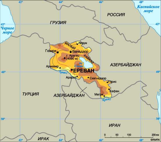
The country is situated in the southwestern part of Asia, occupies the North-East of Armenian plateau - between Caucasus and Near Eest Asia (the territory between the middle flows of the rivers Kur and Araks).
The country is located in the latitude of 38°50' - 41°18' N.
and longitude of 43°27' - 46°37' E
Total area - 29743 km2
--------------------------------------------------------------------------------
--------------------------------------------------------------------------------
State borders:
In the North on Georgia, in the East on Azerbaijan, in the West and South-West on Turkey, in the South on Iran.
--------------------------------------------------------------------------------
The longest extension from North-West to South-East is 360 km, from West to East - 200 km.
The deepest landslide is the Debed Canyon - 390 m,
The highest elevation is the North peak of mount Aragats (4090 m).
Other high elevations:
Kaputdjugh - 3906 m,
Azhdahak - 3598 m,
Spitakasar - 3555 m,
Vardenis - 3522 m.
--------------------------------------------------------------------------------
The longest rivers:
Araks - in the territory of Armenia -158 km (the total length - 1072 km),
Akhuryan 186 km,
Vorotan - in the territory of Armenia -119 km (the total length - 179 km),
Debed - 152 km (the total length - 178 km),
Hrazdan - 141 km,
Aghstev - 99 km (the total length - 133 km)
--------------------------------------------------------------------------------
Lakes:
The largest lake is Sevan - 1239 km2
(1898 m above the sea level),
Arpi - 22.0 km2 (2025 m above the sea level),
Akna - 0.53 km2 ( 3030 m above the sea level),
Sev - 2.0 km2 ( 2666 m above the sea level).
--------------------------------------------------------------------------------
The average temperature
(according to data of the Hydro-meteorological Department of RA):
January - 6.8° C
(the lowest one was registered up to minus 30° C),
July - plus 20.8° С (the highest one was registered up to plus 43° C).
--------------------------------------------------------------------------------
The Republic of Armenia is an independent, democratic state
The president of the Republic is a guarantor for the country independence, territorial integrity and security. In the Republic of Armenia the legislative power is implemented by the National Assembly.
--------------------------------------------------------------------------------
Capital - Yerevan
State language - Armenian
National currency - dram
The basic religion -Christianity
--------------------------------------------------------------------------------
The Basic Holidays and Days of Memory
Christmas and New Year - December 31, January 1,2,6
Army Day - January 28
Women's Day - March 8
Holiday of Motherhood, Beauty and Love - April 7
Genocide Victims' Remembrance Day - April 24
Labor Day - May 1
Victory and Peace Day - May 9
Republic Holiday - May 28
Children's Rights Protection Day - June 1
Constitution Day - July 5
Independence Day - September 21
Earthquake Victims'Remembrance Daу - December 7
Armenia is connected by a regular air communication to many countries. Planes land at Zvartnots airport, located 11 km from Yerevan and capable to accept all types of modern planes.
|
|
 |
|
 |
|
|
|
| |
Счётчик |
|
|
| |
| Пн: |
191 |
| Вт: |
196 |
| Ср: |
199 |
| Чт: |
174 |
| Пт: |
129 |
| Сб: |
2 |
| Вс: |
128 |
| Всего: |
673078 |
| Рекорд: |
1604 |
| OnLine: |
2 |
|
|
|
|